 Reminder!
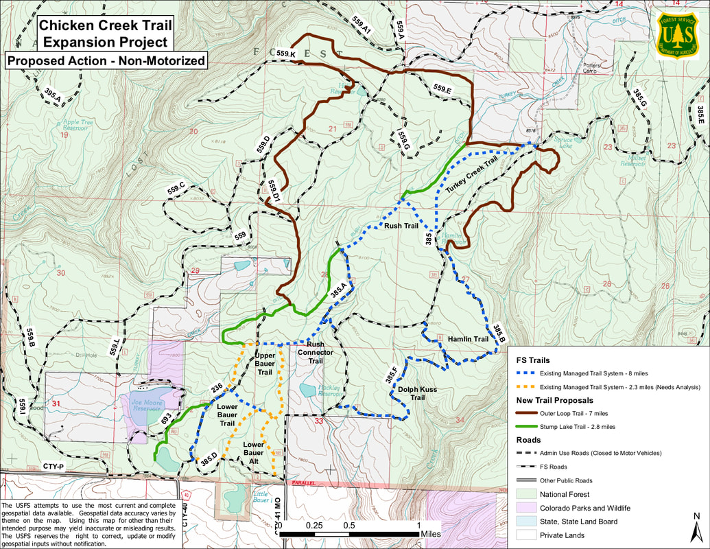
The deadline for submitting comments for the proposed new Chicken Creek trails is Monday July 15. The Forest Service has come out with an Environmental Assessment for the proposed Chicken Creek area trails. (See map above). Comments are being accepted until July 15 so please go to https://www.fs.usda.gov/project/?project=55794 to have your say. You can read the whole draft EA there. The proposal includes approximately 10 miles of new, mostly singletrack non-motorized multi-use trails in the area of Chicken Creek Nordic Ski Area. These trails would be open to non-motorized users including hikers, bikers and equestrians. The proposal also includes 1.25 miles of motorized trails up in the Golconda area. These trails would mostly connect existing motorized trails to form loop options. Thanks for your participation in the public process!
0 Comments
Saturday July 13 Volunteer Trail Work Day
Join Mancos Trails Group Saturday July 13, for a fun and rewarding day clearing brush and repairing drainage features on the West Mancos Trail. We will meet at 8:30am at the Transfer Trailhead just east of the Transfer Campground, up Road 42. Look for the Mancos Trails banner. Depending on the number of volunteers, we’ll divide into groups. Don’t worry, we will take rest breaks for food and water as needed and there is no obligation to complete a certain amount of work. We are required to have fun, socialize, and enjoy a day in the woods with like minded folks and improvement our trails along the way! We’ll plan on being back at the trailhead between 1 and 2PM for burgers and refreshments. Weather: The weather forecast for our location, in the vicinity of Transfer Campground, calls for a high of 78 with a 50% chance of showers and thunderstorms in the afternoon. Please come prepared! Check the forecast yourself on Saturday morning at this link: https://forecast.weather.gov/MapClick.php?lon=-108.20887193031376&lat=37.468101107243285 What to wear: Wear long pants and closed-toe shoes or boots and bring sunglasses or safety glasses, work gloves and rain gear. You know what Southwest Colorado weather can be like, so it's best to be prepared for anything! What to bring:
Where, when and what: We'll meet at 8:30am at the Transfer Trailhead just east of the Transfer Campground. Just drive about 15 minutes up County Road 42 from the intersection with Hwy. 184 in Mancos. Look for the Mancos Trails banner. If you're late: Just check in with the MTG representative at the trailhead for directions. Keep an eye out for more upcoming events on our Facebook page: https://www.facebook.com/MancosTrails/ Things are opening up but many things are still snowed in. The snow line seems to be close to 10,500 – 11,000 feet in the spruce depending on aspect and where you are at in District. Many creeks are still running very high and the West Mancos and West Dolores are still largely impassable. Be careful out there and let me know if you have any additional reports.
Boggy Draw and Sage Hen System – Cleared and Open per SWCCA Chicken Creek Ski Area System – Clear and Open Boggy Draw OHV System – Clear and Open Aspen Loop ATV System – Open except the northern section of trail towards Spruce mill and Windy gap. Chicken Creek Connector 177 – Clear Muleshoe Loop 176 – Clear Rim Trail 613– Clear West Mancos Trail 621 – Clear up to Golconda. FLOOD DAMAGE between Box canyon and Transfer trail. Not passable at this time. Box Canyon Trail 617– Cleared SJTR Box Canyon Spur 171 – Cleared SJTR Coyote Park 191 - Cleared Ramparts Trail 166– Reported as Cleared by SJTR Starvation Creek 167– Cleared Old Gold Run 168 – Cleared to the JCT with Starvation Creek. Bear Creek 607 – Cleared from the trailhead to Little Bear 609 FLOOD DAMAGE at Poly Creek 1/8 mile east of the Gold Run Jct. Trail not passable to horses or dirt bikes. Little Bear Pack Tr 218 – Cleared Priest Gulch 645 – Cleared. Calico 211 – Cleared approx. 4 miles up to the JCT with the School House Trail 660. Salt Creek Trail – Cleared per RTA. Gold Run – Cleared (work happening today) Navajo Lake Trail 635 – Cleared to switchbacks below the lake Burro Bridge Trail 649 – Cleared Stoner Mesa 625 – Cleared Twin Springs East and West 739 and 741- Cleared Eagle Peak 629 – Cleared to snow at 11000ft el approx. 3 miles in. Loading Pen 738 - Cleared  Did you join us for our last group hike on Prater Ridge in June? Or were you unable to make it for that hike? Well, we had so much fun that we're doing it again!
Join us twice next week for double the fun!. Sunday July 7 - Birds and Flowers hike Join Mancos Trails Group for a fun 5-mile hike along the Ramparts Trail. We will be focusing on spotting birds and identifying flowers, so be sure to bring your binoculars and cameras. Meet at 11 am at the corral by the Ramparts Trailhead - take the Echo Basin Road (which turns into Forest Service Road 566) approx. 7 miles to the intersection with FS Road 331 at the T Down Corral. Wednesday July 10 - Evening hike Join Mancos Trails Group for a fun, 4 mile evening hike along the Box Canyon trail. We will meet at the Box Canyon Trailhead just before Transfer Campground at 6:15pm. With sunset so late this time of year we will have plenty of time for this hike. We look forward to seeing you there! |
Archives
July 2024
Categories |
 RSS Feed