|
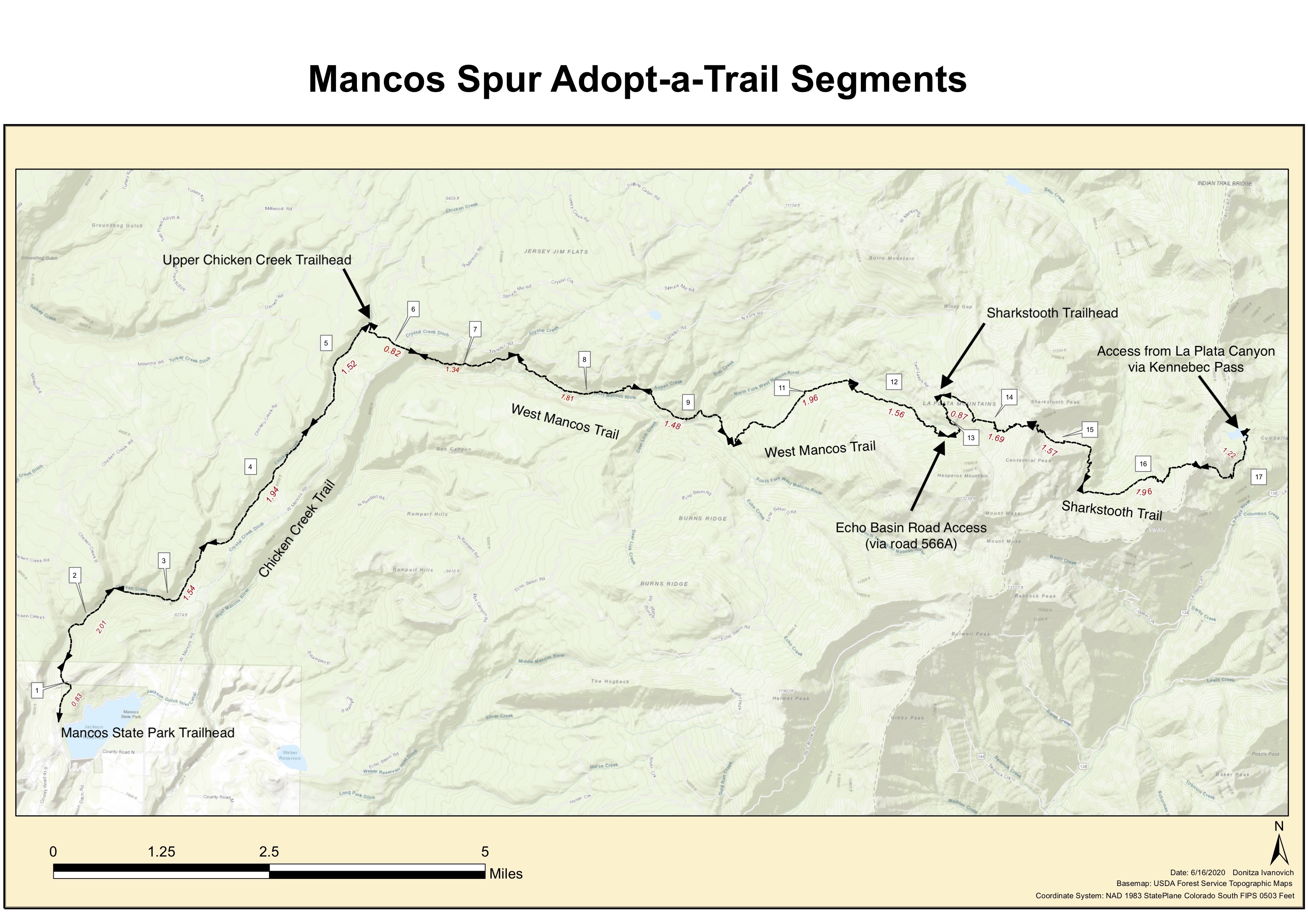
Segment #
1 2 3 4 5 6 7 8 9 10 11 12 13 14 15 16 17 |
Trail Name
Chicken Creek Chicken Creek Chicken Creek Chicken Creek Chicken Creek Chicken Creek West Mancos West Mancos West Mancos West Mancos West Mancos West Mancos West Mancos Sharkstooth Sharkstooth Sharkstooth Sharkstooth |
Description & GPX Download
Mancos State Park Trailhead <-> State Park Boundary sign GPX Segment 1 State Park boundary sign <-> Chicken Creek Connector Jct. "Dean's Sawmill" GPX Segment 2 "Dean's Sawmill" Chicken Creek Connector Jct. <-> Unnamed canyon entering from the north GPX Segment 3 Unnamed canyon entering from the north <-> Rim Trail Jct. GPX Segment 4 Rim Trail Jct. <-> Morrison Trail Jct. GPX Segment 5 Morrison Trail Jct.<-> Upper Chicken Creek TH GPX Segment 6 Transfer TH <-> Crystal Creek drainage crossing GPX Segment 7 Crystal Creek drainage crossing <-> Jct. Golconda Tr. GPX Segment 8 Jct. Golconda Tr. <-> Jct. Owens Basin Connector Trail GPX Segment 9 Jct. Owens Basin Connector Trail <-> Jct. Owens Basin Trail GPX Segment 10 Jct. Owens Basin Trail <-> Jct. North Fork Trail GPX Segment 11 Jct. North Fork Trail <-> approx. 1 mile south of Sharkstooth TH GPX Segment 12 Approx. 1 mile south of Sharkstooth TH <-> Sharkstooth Trailhead GPX Segment 13 Sharkstooth TH <-> Sharkstooth Pass GPX Segment 14 Sharkstooth Pass <-> Jct. Bear Creek Trail GPX Segment 15 Jct. Bear Creek Trail <-> Unnamed Pass between Bear Creek and La Plata Canyons GPX Segment 16 Jct. Unnamed Pass between Bear Creek and La Plata Canyons <-> Jct. Colorado Trail GPX Segment 17 |
Segment Length (approx)
1 mile 1 mile 1.25 mile 1.25 mile 1.5 mile 0.5 mile 1.65 mile 1.65 mile 1.5 mile 0.5 mile 1.75 mile 1.25 mile 1 mile 1.75 mile 1.5 mile 2 miles 1.5 mile |
Elevation
Low elevation segments (7,800-9,000’):
- Segments 1-9 (below Golcanda along the Chicken Creek and West Mancos Trails)
Mid elevation segments (9,000-10,000’):
- Segment 10-11 along the West Mancos Trail
High elevation segments (above 10,000’):
- Segments 12-17 along the Sharkstooth Trail
Driving Access
Easy access, “drive-to-the-trailhead & you’re there” segments:
- Low-clearance access:
- Segment 1 (Mancos State Park Trailhead)
- Segment 5 (Upper Chicken Creek Trailhead)
- Segment 6 (Transfer Trailhead)
- High-clearance access:
- Segment 13 & 14 (Sharkstooth Trailhead)
Hiking Access
Segments approx 1-1 ½ mile hike from trailhead:
- Segments 2 & 4 along the Chicken Creek Trail (low clearance access)
- Segments 7 along the West Mancos Trail
- Segment 12 along the West Mancos Trail
- Segment 13 along the Sharkstooth Trail (High-clearance access)
- Segment 17 along the Sharkstooth Trail (High-clearance 4WD from the Kennebec Pass Trailhead)
Segments more than approx. 1-1 ½ mile hike from trailhead:
- Segment 3 & 4 along the Chicken Creek Trail
- Segment 8 & 12 along the West Mancos Trail
- Segment 15 & 16 along the Sharkstooth Trail (High-clearance access)
ATV and Two-Wheel Motorized Access
Two-wheel motorized access
- Segment 5 & 6 along the Chicken Creek Trail
- Segment 9, 10 & 11 along the West Mancos Trail
ATV access
- Segment 8 & 9 along the West Mancos Trail (note that you can get to the end of the segment by ATV from Golcanda, but the segment itself is not open to ATVs. Segment 9 is open to motorcycles, Segment 8 is open to non-motorized travel.)