Enjoy 12 miles of single-track, plus over 10 additional miles of existing double-track
The Chicken Creek Trail System provides fantastic family-friendly hiking, horseback riding and mountain biking in the ponderosa pines and is a gateway to higher elevation trails. These loops are beginner friendly. Dogs are allowed. This area is also well known for its groomed cross-country skiing during the winter months.
In Summer 2021-22, local volunteers along with crews from the Forest Service and Southwest Conservation Corps put in thousands of hours to hand-build 12 new miles of single-track for Mancos! The result is the new Blue Jay Trail and the Lost Chicken Trail in the Chicken Creek area. The fun level is HIGH! There are a number of great possible loops that utilize the new trails. Click on the map to download it to your device or to print it and take it with you while you hike or ride.
The trails generally run gradually uphill from southwest to northeast, with about 750' elevation gain from the lowest point at the Chicken Creek Trailhead to the highest at the easternmost point along the Lost Chicken Trail. Most of the trails are considered easy for all users, though there are a short few technical sections. Downhills are fast and fun!
Remember these are multi-use, non-motorized trails (sorry, no ebikes!) so be courteous aware of other users.
Loop ideas:
The Whole Chicken (15.2 miles, 750' elevation change). Begin at the Chicken Creek trailhead and follow the Blue Jay Trail to its first intersection with the Lost Chicken Trail. Head left (west) and follow the entire Lost Chicken Trail until it intersects with the Hamlin Trail. Take the Hamlin Trail to the right (north) to join the main Chicken Creek Road. Follow the Chicken Creek Road north for a approx. 0.2 miles and go left (NW) on the North Rush Connector Trail, which will rejoin the Blue Jay Trail. Take the Blue Jay Trail left (south) to return to the trailhead. Note that the Whole Chicken can be done counter-clockwise as well, but the climb on Lost Chicken East is steeper than on Lost Chicken West. But the downhill on Lost Chicken West is longer!
Half Chicken West (Blue Jay/Lost Chicken West lollipop) (approx. 12 miles, 700' elevation change). Begin at the Chicken Creek trailhead and follow the Blue Jay Trail to the top. Follow the Lost Chicken Trail to the west to return to the Blue Jay trail, then follow the Blue Jay trail south back to the trailhead.
Half Chicken East (Blue Jay/Lost Chicken East lollipop) (approx. 8 miles, 750' elevation change). Begin at the Chicken Creek trailhead and follow the Blue Jay Trail to the top. Follow the Lost Chicken Trail to the east to join the Hamlin Trail. Take the Hamlin Trail to the right (north) to join the main Chicken Creek Road. Follow the Chicken Creek Road north for a approx. 0.2 miles and go left (NW) on the North Rush Connector Trail, which will rejoin the Blue Jay Trail. Take the Blue Jay Trail left (south) to return to the trailhead.
Many other longer and shorter loops exist using the existing trails and roads - be creative!
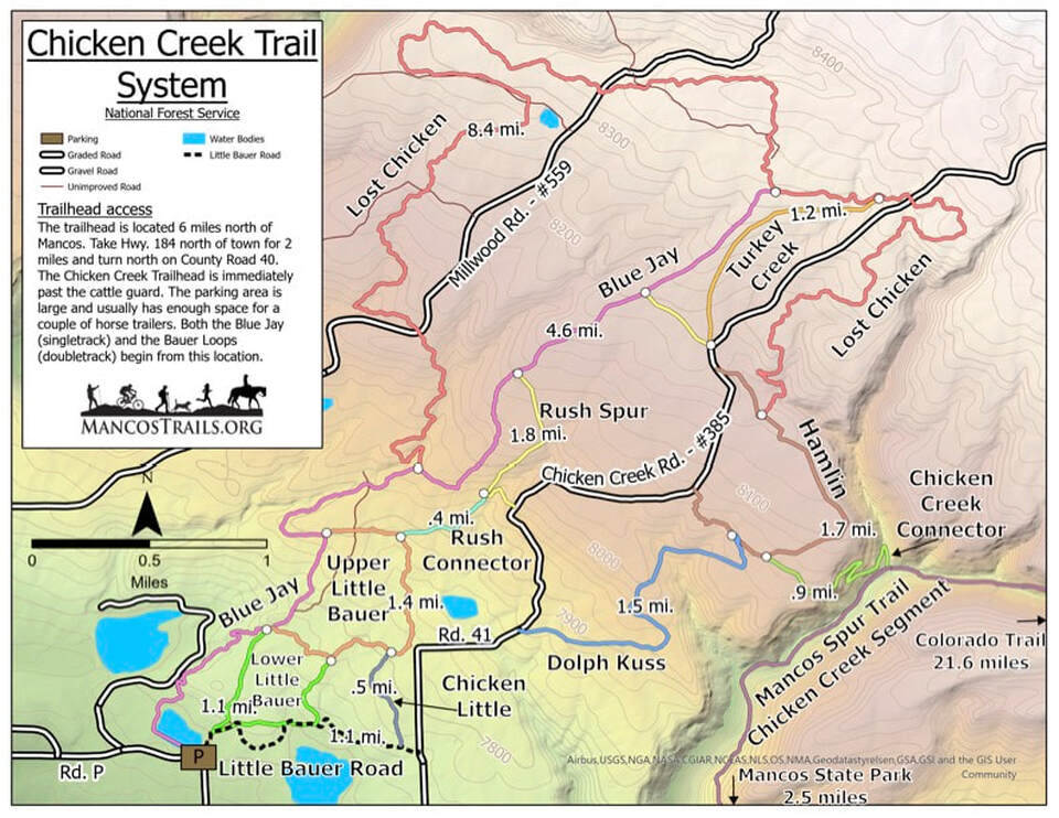
Trailhead access
The trailhead is located 6 miles north of Mancos. Take Hwy. 184 north of town for 2 miles and turn north on County Road 40. The Chicken Creek Trailhead is immediately past the cattle guard. The parking area is large and usually has enough space for a couple of horse trailers. Both the Blue Jay (singletrack) and the Bauer Loops (doubletrack) begin from this location.
Access to the Mancos Spur to the Colorado Trail (via Chicken Creek Trail) or to Mancos State Park
From the Hamlin Trail you can take the Chicken Creek Connector trail to connect to the Mancos Spur Trail (Chicken Creek Trail segment). Heading north on the Mancos Spur/Chicken Creek Trail will take you to Transfer Campground and on to the West Mancos Trail segment of the Mancos Spur, and eventually connect you to the Colorado Trail at 11,600' elevation. From there, you can walk to Denver or Durango, or connect to the Continental Divide Trail to walk to Canada or Mexico!
If you head south on the Mancos Spur/Chicken Creek Trail for two miles, you will join the trail system at Mancos State Park. The trailhead for the Mancos Spur to the Colorado Trail is in Mancos State Park.
The Whole Chicken (15.2 miles, 750' elevation change). Begin at the Chicken Creek trailhead and follow the Blue Jay Trail to its first intersection with the Lost Chicken Trail. Head left (west) and follow the entire Lost Chicken Trail until it intersects with the Hamlin Trail. Take the Hamlin Trail to the right (north) to join the main Chicken Creek Road. Follow the Chicken Creek Road north for a approx. 0.2 miles and go left (NW) on the North Rush Connector Trail, which will rejoin the Blue Jay Trail. Take the Blue Jay Trail left (south) to return to the trailhead. Note that the Whole Chicken can be done counter-clockwise as well, but the climb on Lost Chicken East is steeper than on Lost Chicken West. But the downhill on Lost Chicken West is longer!
Half Chicken West (Blue Jay/Lost Chicken West lollipop) (approx. 12 miles, 700' elevation change). Begin at the Chicken Creek trailhead and follow the Blue Jay Trail to the top. Follow the Lost Chicken Trail to the west to return to the Blue Jay trail, then follow the Blue Jay trail south back to the trailhead.
Half Chicken East (Blue Jay/Lost Chicken East lollipop) (approx. 8 miles, 750' elevation change). Begin at the Chicken Creek trailhead and follow the Blue Jay Trail to the top. Follow the Lost Chicken Trail to the east to join the Hamlin Trail. Take the Hamlin Trail to the right (north) to join the main Chicken Creek Road. Follow the Chicken Creek Road north for a approx. 0.2 miles and go left (NW) on the North Rush Connector Trail, which will rejoin the Blue Jay Trail. Take the Blue Jay Trail left (south) to return to the trailhead.
Many other longer and shorter loops exist using the existing trails and roads - be creative!
Trailhead access
The trailhead is located 6 miles north of Mancos. Take Hwy. 184 north of town for 2 miles and turn north on County Road 40. The Chicken Creek Trailhead is immediately past the cattle guard. The parking area is large and usually has enough space for a couple of horse trailers. Both the Blue Jay (singletrack) and the Bauer Loops (doubletrack) begin from this location.
Access to the Mancos Spur to the Colorado Trail (via Chicken Creek Trail) or to Mancos State Park
From the Hamlin Trail you can take the Chicken Creek Connector trail to connect to the Mancos Spur Trail (Chicken Creek Trail segment). Heading north on the Mancos Spur/Chicken Creek Trail will take you to Transfer Campground and on to the West Mancos Trail segment of the Mancos Spur, and eventually connect you to the Colorado Trail at 11,600' elevation. From there, you can walk to Denver or Durango, or connect to the Continental Divide Trail to walk to Canada or Mexico!
If you head south on the Mancos Spur/Chicken Creek Trail for two miles, you will join the trail system at Mancos State Park. The trailhead for the Mancos Spur to the Colorado Trail is in Mancos State Park.