The Madden Peak Road accesses several trails and is located is just 6 miles east of Mancos on the north side of Hwy 160 at the very top of Mancos Hill.
Trails include the Railroad Grade, Old Gold Run and Starvation Creek. In addition, you can drive to the top of the road to hike up to the summit of 11,654' Madden Peak. Not a designated trail but a route, it's a fairly easy ridge hike to the top and is usually one of the first peaks in the La Platas to be accessible in the spring. Note that the road becomes very rough a few miles in and is slow going. High clearance is recommended.
Trails include the Railroad Grade, Old Gold Run and Starvation Creek. In addition, you can drive to the top of the road to hike up to the summit of 11,654' Madden Peak. Not a designated trail but a route, it's a fairly easy ridge hike to the top and is usually one of the first peaks in the La Platas to be accessible in the spring. Note that the road becomes very rough a few miles in and is slow going. High clearance is recommended.
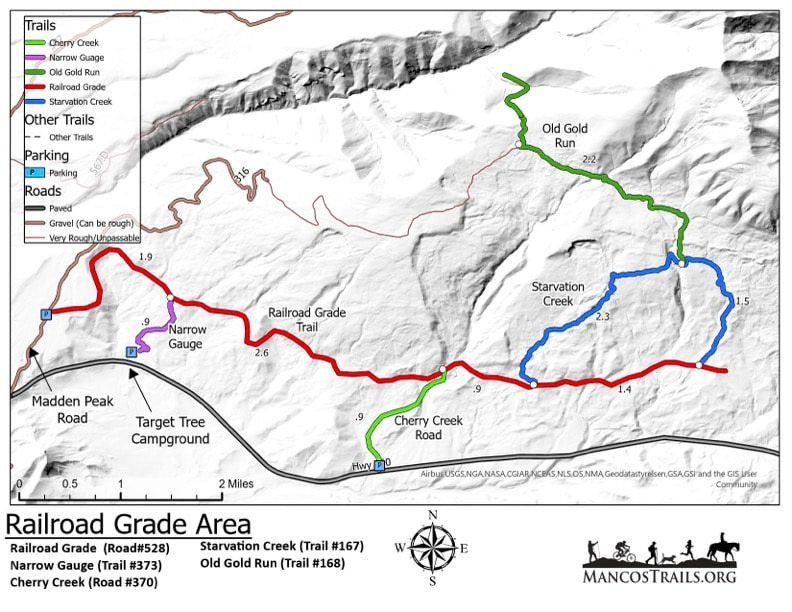
Click the map to download a high-quality pdf to print out at home. Or, download it to a free mapping app like Avenza to locate yourself using your phone's GPS.
Railroad Grade Trail
This trail is accessed from the Madden Peak Road or from the east via the Cherry Creek Trailhead. There is a small parking area at the Forest Service Boundary. This trail offers a wide and less technical route that follows the old railroad grade. There are a few small creek crossings and rutted stretches.
This trail is accessed from the Madden Peak Road or from the east via the Cherry Creek Trailhead. There is a small parking area at the Forest Service Boundary. This trail offers a wide and less technical route that follows the old railroad grade. There are a few small creek crossings and rutted stretches.
Railroad grade (Cherry Creek) on Trailforks.com
ustom HTML
Old Gold Run Trail
Accessed from the Madden Peak Road, the Old Gold Run Trail starts with thick stands of aspen and mature pines sprinkled with a few short creek splashdowns. After a short climb up from Starvation Creek at the trails midway point, get ready for continuous fast curvy flow down through endless alpine flowers and scrub oak.
Starvation Creek Trail
You can take either direction as both lead back down to the Railroad Grade. The downhill can be incredibly rocky and loose. Please close the cattle gates behind you. This trail can also be ridden/hiked by itself, accessed from the Railroad Grade.
You can take either direction as both lead back down to the Railroad Grade. The downhill can be incredibly rocky and loose. Please close the cattle gates behind you. This trail can also be ridden/hiked by itself, accessed from the Railroad Grade.
Madden Peak Summit hiking route
This is a route, not an official trail. You'll need a high clearance vehicle to get all the way to the trailhead. Park just past the Old Gold Run Trailhead at 8.4 miles up the Madden Peak Road. If you don't have high clearance you can park about 1.5 miles lower on the road. and follow the obvious route the the northeast up Madden Peak. It's pretty steep but easy to follow. Watch out, but the section just before the summit is loose scree and talus so be careful!
This is a route, not an official trail. You'll need a high clearance vehicle to get all the way to the trailhead. Park just past the Old Gold Run Trailhead at 8.4 miles up the Madden Peak Road. If you don't have high clearance you can park about 1.5 miles lower on the road. and follow the obvious route the the northeast up Madden Peak. It's pretty steep but easy to follow. Watch out, but the section just before the summit is loose scree and talus so be careful!
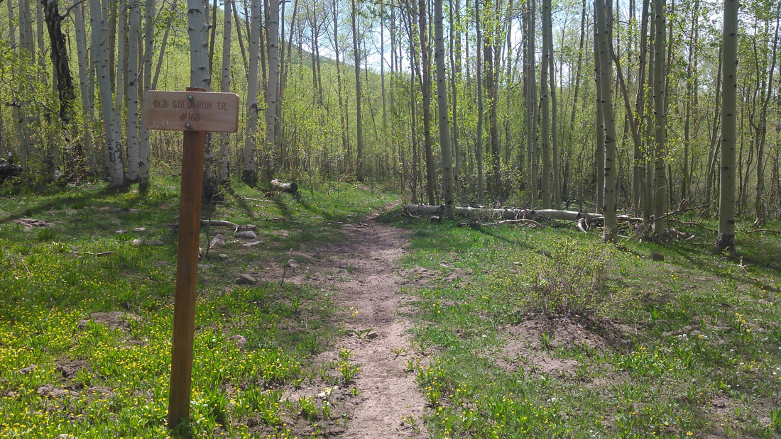
Old Gold Run Trail